
Watershed Planning, Assessment, and Restoration
NRS’ Watershed Program works with diverse partners in California’s north coast region to find common solutions to ecosystem degradation, sea level rise, and salmonid habitat problems while balancing socio-economic needs and environmental quality. Our mission is to restore local watersheds, protect water quality, and promote healthy communities. In the last three decades, NRS' Watershed Program has designed and implemented several hundred fisheries enhancement, water quality improvement, riparian and wetland restoration, erosion and sediment control, urban stream, and educational projects on the north coast to improve conditions for fish, wildlife, and people.
Coastal Dunes Restoration

Project Titles:
North Spit Dunes Resilience
Restoring Biodiversity at Wadulh Dunes
Building Resiliency and Restoring Critical Habitat in a Northern California Dune System
Division: Watershed
Project Dates: 2024-2028
Funders: California State Coastal Conservancy (SCC), California State Wildlife Conservation Board (WCB), National Fish and Wildlife Foundation (NFWF), US Fish and Wildlife Service (USFWS)
Project Partners: USFWS, Wiyot Tribe, SCC, WCB, NFWF, Friends of the Dunes (FOD), American Conservation Experience (ACE), Mattole Restoration Council (MRC), Samara Restoration, DZC Archaeology, and GR Sundberg, Inc.
Services: Dune ecological restoration, invasive plant removal, native plant species planting, nesting bird surveys, dune re-contouring, sand transport control.
RCCA in collaboration with the USFWS is spearheading one of the largest coastal dune restoration efforts on the Pacific Coast. Thanks to substantial funding from NFWF, SCC, and WCB, this project is restoring dunes that span from the Samoa Peninsula north to Lanphere and Ma-le’l Dunes. Restoration managers are targeting invasive species that have disrupted the dune ecosystem's natural balance. European beachgrass (Ammophila arenaria) has particularly stabilized the foredunes, hindering sand movement and making the dunes more susceptible to rising sea levels and fiercer storms. This threatens both human infrastructure and essential natural and cultural resources. Additionally, yellow bush lupine (Lupinus arboreus) and other invasive plants have crowded out the native dune mat community, altering its diversity and the resources it provides. The project's main goals include removing invasive species and reintroducing native plants, for example, American dune grass (Leymus mollis), yarrow (Achillea millefolium), and dune buckwheat (Eriogonum parvifolium). To achieve this, crews use various methods such as hand-pulling, targeted herbicide application, brush cutting, heavy equipment, and controlled burning. Each strategy is part of an integrated pest management system designed for specific conditions. This project aims to restore natural dune processes, boosting resilience against the impacts of climate change.
Tuluwat Island Spartina Removal Project

Project Dates: 2022 – 2029
Division: Watershed
Funder: Humboldt Bay Harbor, Recreation, and Conservation District
Project Partners: CalTrans, Humboldt Bay Harbor District, Wiyot Tribe, ICF, DZC Archaeology, Ross Taylor and Associates
Services: saltmarsh restoration, invasive plant removal, nesting bird surveys, biological monitoring
The Tuluwat Spartina Removal Project is ambitiously restoring 178 acres (63%) of the island’s land mass that was overrun by invasive Spartina densiflora (spartina or cord grass), with the goal of returning vital saltmarsh habitat to the island. The project serves as mitigation for impacts potentially caused by the Eureka-Arcata Corridor Project. Tuluwat Island holds immense cultural significance for the Wiyot Tribe as the heart of the Wiyot Universe. After 160 years of varied and sometimes damaging land use—including use as pastureland, a ship repair facility, and a toxic waste dump—the island was returned to the Wiyot Tribe by the City of Eureka in 2019. RCAA NRS was entrusted by the Tribe to restore the island's vegetation community and revitalize its original ecological balance. By employing innovative techniques such as using a Marsh Master to till and remove large areas with spartina as well as using human-powered brush cutters in hard-to-reach areas, RCAA NRS is making significant strides in Tuluwat Island restoration.
Jacoby Creek
Project Title: Jacoby Creek Off-Channel Refuge and Rearing Habitat Planning Project
Division: Watershed
Project Dates: 2022-2024
Funder: California Department of Fish and Wildlife’s (CDFW) Fisheries Restoration Grant Program (FRGP)
Project Partners: Michael Love and Associates, Thomas Gast & Associates Environmental Consultants, Pacific Watershed Associates, CDFW
Service: Salmonid habitat restoration (site plan development)
The Jacoby Creek Coho Off-Channel Refuge and Rearing Habitat Planning Project (Phase Two)is in the implementation phase. A new off-channel alcove will provide juvenile salmonids with refuge during winter high-flow events and increased quality rearing habitat during the early summer months. This project intends to provide long-term benefits and climate resiliency, biodiversity, and sensitive species recovery. Coho salmon (Oncorhynchus kisutch) are the species targeted to benefit from this project, however, restoration of this section of Jacoby Creek will benefit many other native species. The project team led by RCAA performed site characterization through surveys, mapping, and geologic, hydrologic, water quality, and botanical site assessments. Hydraulic analysis, wood stability calculations, and engineering designs contributed to the final project design. Additionally, a revegetation plan has been created to enhance habitat quality and stream function. Finally, a project monitoring plan wascreated to assess effectiveness and enable adaptive management.
Martin Slough Enhancement

Project Titles: Martin Slough Enhancement Project and Martin Slough Flow Enhancement Planning
Division: Watershed
Project Dates: 2014, 2018-2021, 2022-present
Funders: California State Coastal Conservancy, Ocean Protection Council, State Wildlife Conservation Board, US Fish and Wildlife Service, National Oceanic and Atmospheric Administration, California Department of Fish and Wildlife, California Department of Water Resources, California Department of Transportation Environmental Enhancement and Mitigation Program
Project Partners: Northcoast Regional Land Trust, City of Eureka, Michael Love and Associates, Thomas Gast and Associates Environmental Consultants, GHD, Inc., Ross Taylor and Associates, Watershed Stewards Program, California Conservation Corps, Community Volunteers
Services: salmonid habitat restoration, tidal slough restoration, fish and wildlife habitat restoration, invasive plant removal, native saltwater, brackish, and freshwater marsh and riparian vegetation restoration
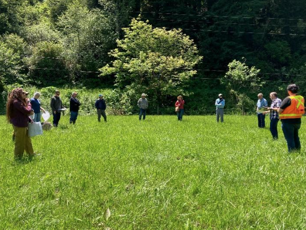
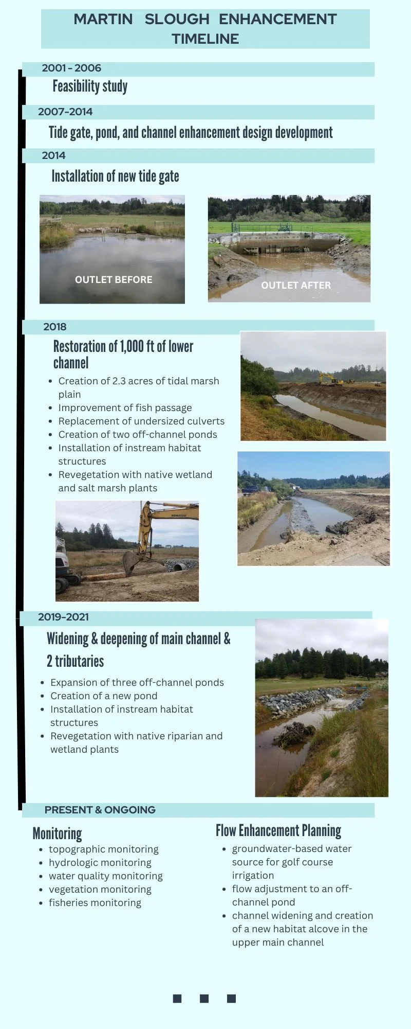
The Martin Slough Enhancement Project was designed to enhance habitat for coho salmon and reduce flooding of recreational and agricultural lands. The project encompasses two properties: 40 acres of pasture currently owned by the Northcoast Regional Land Trust (NRLT) and 120 acres owned by the City of Eureka and managed as the Eureka Municipal Golf Course and includes approximately 2 miles of main slough and slough tributary channels. RCAA, in partnership with many key partners, led the Martin Slough Enhancement Project that began with a feasibility study in 2001. The first 13 years of this project were dedicated to site characterization and design plan development. New tide gates were installed in 2014 and channel reconstruction began in 2018. In addition to tide gates, enhancements included replacement of undersized culverts, creation of a tidal marsh plain, widening and deepening the channels, creation of off-channel ponds, installation of instream habitat structures, and planting native salt marsh and riparian revegetation (see the timeline for more construction details). Throughout the project various types of physical and biological monitoring have been conducted to validate project outcomes and monitor habitat improvements. This monitoring is currently ongoing, and annual monitoring reports, beginning in 2019, are available.
Download Martin Slough Enhancement Project 2023 Monitoring Report here
The Martin Slough Enhancement Project vastly improved the aquatic and terrestrial habitats of lower Martin Slough for juvenile coho, tidewater goby, amphibians, and other fish and wildlife species. Restoration has increased accessibility of the golf course throughout much of the year by reducing the impacts of prolonged flooding.
The current project, Martin Slough Flow Enhancement Planning, will allow for additional instream habitat improvement, and develop a ground-based water source for golf course irrigation.
Ryan Creek

“A view of the Ryan Creek wetland from 2021, prior to any project construction."
Project Title: Lower Ryan Creek Off-Channel Habitat and Floodplain Enhancement Planning Project
Division: Watershed
Project Dates: 2022-2024
Funder: California Department of Fish and Wildlife’s (CDFW) Fisheries Restoration Grant Program (FRGP)
Project Partners: CDFW, Michael Love and Associates (MLA), Thomas Gast and Associates Environmental Consultants (TGAEC), Pacific Watershed Associates, GHD, Inc., Wildling Design Studio
Service: Salmonid habitat restoration (site plan development)
In 2021, RCAA secured funding from CDFW’s FRGP for an off-channel habitat planning project in Ryan Creek, one of five feasible sites identified for rebuilding such habitat by MLA and TGAEC in 2020. Ryan Creek is located about 5 miles upstream from Humboldt Bay. The project site includes both Ryan Creek and Cutten Branch, both of which flow into Ryan Slough and eventually Humboldt Bay and is within Humboldt County’s McKay Community Forest. This project will develop final design plans for off-channel wetland features, improved hydrologic connectivity between lower Ryan Creek, tributaries, and freshwater wetlands, enhanced rearing habitat for juvenile salmonids, and improved conditions for native plants and wildlife. The project also will create year-round habitat for juvenile coho salmon (Oncorhynchus kisutch) and help prevent fish strandings through pond construction and improved hydrologic connectivity. This plan aligns with the Southern Oregon-Northern Coastal California Coho Salmon Final Recovery Plan, ensuring a comprehensive region-wide approach to coho salmon recovery.
2022 Lightning Complex Burned Area Response

A dozer line winds off to the right, within Six Rivers National Forest.
Project Title: 2022 Lightning Complex Burned Area Response Weed Treatment and Seed Collection
Project Date: 2024
Division: Watershed
Funder: Burn Area Response (BAR) funding via the USDA Forest Service (USFS)
Project Partners: Six Rivers National Forest
Service: invasive/noxious plant removal, seed collection, plant survey/data collection
Beginning in 2005, RCAA and the USFS collaborated to manage non-native invasive plant species. Recently, NRS staff have surveyed and treated invasive plants along 62 miles of dozer lines created during fire suppression activities in the 2022 Six Rivers National Forest (SRNF) Lightning Complex fire. During forest fires, dozers are used to create lines of bare earth free of vegetation to slow down a fire’s spread. Dozer lines, while effective in containing fires, create ideal conditions for invasive species to thrive, posing threats to native ecosystems. Common invasives encountered within dozer lines include Himalayan blackberry (Rubus armeniacus), bull thistle (Cirsium vulgare), English ivy (Hedera helix), cheatgrass (Bromus tectorum), Scotch thistle (Onopordum acanthium), leafy spurge (Euphorbia esula), and French broom (Genista monspessulana). These invasives disrupt ecosystem functions, alter wildfire disturbance regimes, reduce biodiversity, impact native wildlife food sources, increase soil erosion, and decrease overall forest productivity. RCAA continues invasive plant dozer line surveys, treats invasive plants and noxious weeds, and collects native plant seeds to help control the spread of invasive plants within our National Forests.